
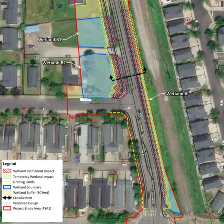
Geographic Information Systems (GIS) Data Integration That Drives Efficiency & Productivity.

Geographic Information Systems (GIS) blends creativity and science, deepening our understanding of the ground beneath our feet and all that surrounds us. GIS offers far more insight than an ordinary map—it tells the story of the earth. Utilizing GIS, we get a visual representation of complex thoughts and analyses which reveal valuable insights that support better decision-making for our staff and clients. 

Geographic Information System map of industrial port and surrounding buildings and typography

Our areas of GIS expertise:

Data Acquisition

We specialize in field data collection for environmental permitting and analysis, using advanced hardware and software, including GPS units, Field Maps, Survey123, and Bio App. By integrating base layers such as tax lots, soils, LiDAR, and wetland data, we ensure accuracy and efficiency in data collection.

  • Infrastructure/asset mapping
  • Wetland, water, and wildlife habitat mapping
  • Data integration from various sources (e.g. CAD, raster, vector)
Geographic Information Systems (GIS) map of wetlands

Database Design & Management

By integrating spatial intelligence into the database process, our GIS team ensures the data is not only well-structured but also geographically accurate and optimized for spatial analysis.

  • Database design and implementation
  • Complying with client database requirements
  • Database management and maintenance

Mapping & Visualization

We create detailed maps and figures to visualize project data and communicate insights effectively. These visuals are essential for permitting, public involvement, and client reports.

  • Key issues maps
  • Public involvement tools
  • Permit application graphics


Spatial Data Analysis

Our team transforms raw data into actionable insights through advanced geospatial analysis. This includes evaluating wetlands, zoning impacts, and infrastructure risks to develop comprehensive solutions using ArcGIS Pro and Global Mapper.

  • Site selection and routing analysis
  • Infrastructure siting
  • Impact assessments and calculations 
  • Analyzing patterns and relationships between many different data layers


Workflow Enhancement

By leveraging GIS and spatial data we drive workflow efficiency and field-based access to critical project information.

  • Connecting clients with field and office work
  • Connect systems, workflows, and people
  • Streamline job site reporting
  • Share crucial project data directly from the field